Kameshtashtan-natuashu
Print
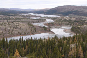
The view of the natuashu (steady) downstream along Kameshtashtan-shipu. The view is to the north towards the junction of Ashuapun-shipu and Emish-shipu. A traditional Innu travel route from Kameshtashtan left the river here, portage to the right of the photo, over to a brook draining into Nutakuanan-shipu. Photo courtesy Stephen Loring.
2006
Full Size Image
The view of the natuashu (steady) downstream along Kameshtashtan-shipu. The view is to the north towards the junction of Ashuapun-shipu and Emish-shipu. A traditional Innu travel route from Kameshtashtan left the river here, portage to the right of the photo, over to a brook draining into Nutakuanan-shipu. Photo courtesy Stephen Loring.
ID: 641
Longitude: -63.0192
Latitude: 55.9776
Pronunciation: ka:mesta:stn-na:twa:ʃu:Pronunciation
Translation: Where it is All Blown Away Lake
Feature: lake

Explanation:
Named in reference to river Kameshtashtan-shipu (no 267). The lake results from the widening of the river.